Your land is buildable if it has legal access, zoning that allows a home on a lot its size, a way to get water and handle sewage (public sewer or soil that passes a septic evaluation), and a building site outside the floodway and wetlands with no recorded restriction against it. Most of that you can check free, online, in an afternoon.

Own land in one of our eight build markets? Get a written cash offer within one business day.
Get a land offer →Educational only. This explains how these situations generally work. It is not legal, tax or financial advice, and the rules differ by state — talk to an attorney or CPA about your own situation before you act on any of it.
Land is priced on what can be built on it, and a buildable lot is usually worth far more than the same ground with no way to build. A builder or buyer looks at your parcel and asks one question first: can a house legally go here, and what will it cost to get to the point where it can? Every item they cannot answer from the paperwork becomes a risk, and a risk becomes either a lower number, a longer due-diligence period or a pass.
Here is how one unknown moves a price. The figures are illustrative, not a quote. Say a lot is worth $200,000 if a conventional septic system works. If the soil needs an engineered system instead, assume that costs about $30,000 more, so the lot is worth about $170,000. If the soil cannot take any system, the land might only sell to a neighbor or as recreation land, say $40,000. A buyer who does not know which of those is true has three choices: pay for testing and wait, offer something near the bad case, or walk. A soil evaluation that settles the question can change the price by far more than it costs.
If you are wondering how to tell if land is buildable before a buyer does, the checks below run in the order that most often ends a deal. Most of the early ones are free and take an afternoon online. Our guide to what your land is worth covers the pricing side once you have the answers, and if you would rather someone else run the checks, you can send us the parcel number and we will look at the maps ourselves.
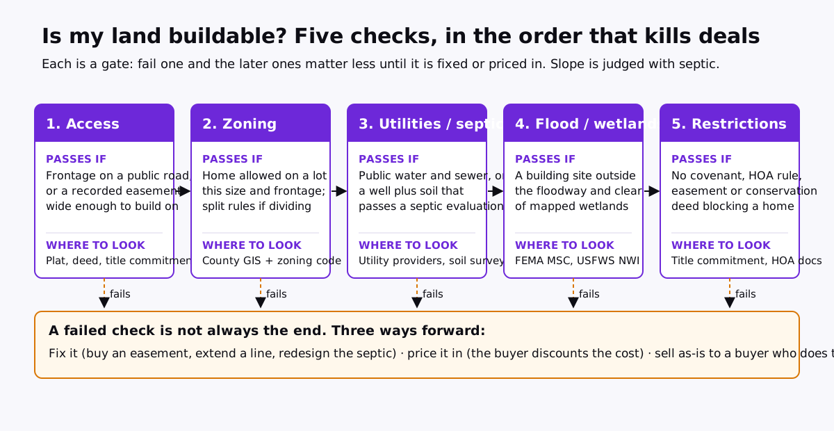
The first question is whether you can legally get from a public road to the building site. There are three situations:
Where to look: your deed and any recorded plat, the county GIS parcel map, and a title commitment, which lists recorded easements. A recent survey answers most of it.
Zoning decides whether a home is allowed at all and on how much land. Look up the parcel on the county or city GIS zoning layer, then read that district in the zoning ordinance for minimum lot size, minimum road frontage, setbacks and permitted uses.
If you plan to sell a piece rather than the whole parcel, subdivision rules matter as much as zoning. Splitting land usually needs a survey and a plat or a formal lot split, and some counties require each new lot to have its own frontage and its own septic site. In Texas, land outside city limits may sit in a city’s extraterritorial jurisdiction (ETJ), where the city’s subdivision rules can apply; since September 1, 2023, Senate Bill 2038 lets many landowners petition to be released from an ETJ. Our Collin County page covers how that plays out there.
Ask each provider two questions in writing: is service available to this parcel, and what would it cost to extend it? An email reply is fine. A written availability or “will serve” letter from a water provider carries more weight with a buyer than a phone call.
Water can be the whole question in the desert. In Washington County, Utah, the Washington County Water Conservancy District charges a water impact fee that is due when a building permit is secured; its published residential fee in September 2026 was $11,413 for homes meeting its ultra water-efficiency standards and $17,266 otherwise, and a paid fee cannot be moved to another lot. A written assurance from the water provider that it will serve the parcel is one of the first things a buyer there will ask for. Fees change, so check the current schedule with the district. More on our Washington County page.
Without public sewer, the home needs an onsite septic system, and whether one fits depends on the soil. The EPA’s septic systems hub explains how these systems work. Permits are issued by the state or county health or environmental department, not the EPA.
Start with a free screen. The USDA’s Web Soil Survey covers most US counties: draw your parcel, then look under the suitability ratings for septic tank absorption fields. Treat the answer as a flag, not a verdict; the survey itself says some uses need an onsite investigation. A soil scientist’s evaluation or a perc test is what the permitting office accepts.
Local rules can be stricter than people expect. Williamson County, Tennessee runs its own Department of Sewage Disposal Management. Its regulations require the soils on a parcel to be assessed in an approved manner before a septic construction permit is issued; soil mapping may only be done by a department-approved soil consultant, drawn on a plat prepared by a Tennessee-registered land surveyor; perc tests are allowed only for single-family homes; and the system needs a duplicate area preserved for future repair. Soils on slopes steeper than 35% cannot be used for a system. That is why, all else equal, a buyer will pay more for a Williamson County lot with an approved soil map than for one without.
What the result changes: a conventional system, an engineered or alternative system at a higher cost, or no house at all. It also decides how many lots a larger parcel can become, because each one needs its own approved area.
Look the parcel up on FEMA’s Flood Map Service Center. Three answers matter. Zone X means the parcel is outside the mapped 1%-annual-chance flood area. A Special Flood Hazard Area, such as Zone A or AE, means building is often allowed but with elevation requirements and flood insurance for a financed home. The regulatory floodway, the channel that carries the flood itself, is where new homes are usually ruled out in practice. What counts is where the building site sits, not whether a corner of the parcel is shaded.
For wetlands, screen with the U.S. Fish & Wildlife Service’s National Wetlands Inventory mapper. It is a screening map built largely from aerial imagery, not a legal boundary; a wetland consultant’s delineation is what permitting agencies rely on. In St. Johns County, Florida, building in or filling wetlands generally runs through an environmental resource permit from the St. Johns River Water Management District, which covers the northeast of the state. See our St. Johns County page.
Some counties add an overlay you will not find on a flood map. In Comal County, Texas, much of the land lies on the Edwards Aquifer recharge, transition or contributing zones regulated by the Texas Commission on Environmental Quality under 30 TAC Chapter 213. TCEQ says that before building on those zones a plan must be reviewed and approved by its Edwards Aquifer Protection Program, with up to 30 days for administrative review and 90 days for technical review of a complete application. How the rules apply to a single home depends on the zone and the project, so ask TCEQ about your parcel.
Steep land costs more to build on and sometimes cannot take a septic field at all. Look at the contour layer in the county GIS, then walk the land. Ask three questions: is there a reasonably level building pad, can a driveway reach it at a grade a car and a fire truck can climb, and is there enough gently sloped ground for a septic field? Williamson County’s 35% limit on septic soils is one concrete example of slope becoming a hard stop.
Recorded documents can limit what is built even when everything above passes. A title commitment lists them. Look for:
Drainage can take more land than people realize. In Hamilton County, Indiana, many parcels are crossed by county-regulated drains. Under Indiana Code 36-9-27-33, the county surveyor and drainage board have a right of entry within 75 feet of a regulated drain, measured from the center line of a tile drain or the top of each bank of an open drain, and permanent structures may not be placed in that strip without the board’s written consent. The statute allows that width to be reduced in some cases. A strip up to 150 feet wide, plus the ditch itself, running through the middle of a parcel changes where a house can go. See our Hamilton County page.
| Check | Where to look | Free or cost | What it changes |
|---|---|---|---|
| Legal access | Deed, recorded plat, title commitment, county GIS | GIS free; title commitment or survey paid | No access usually means no building permit and a much smaller buyer pool |
| Zoning and lot size | County or city GIS zoning layer, zoning ordinance, planning office | Free | Whether a home is allowed at all and how many lots the land can become |
| Water, sewer, power | Utility providers; ask for availability and extension costs in writing | Usually free to ask; extensions and fees paid by whoever builds | Sewer at the road versus none is often the biggest single swing in value |
| Septic feasibility | USDA Web Soil Survey to screen; soil scientist or perc test to confirm | Screen free; field testing paid | Conventional system, engineered system, or no house |
| Flood zone | FEMA Flood Map Service Center; county floodplain administrator | Free | Floodway usually rules building out; a mapped flood zone adds elevation and insurance cost |
| Wetlands | USFWS National Wetlands Inventory to screen; wetland consultant to delineate | Screen free; delineation paid | Shrinks or moves the building site; may need a permit |
| Slope | Topographic layer in county GIS; a site visit | Free | Driveway, grading and septic cost, and whether a septic field fits |
| Restrictions and easements | Title commitment, recorded covenants, HOA documents, recorded easements | Title commitment paid (often by the buyer) | What can be built, where, and whether it can be divided |
You do not have to answer every question before selling, but each one you answer removes a reason for a buyer to discount. In rough order of cost:
The alternative is to sell as-is to a buyer who does that work. Restar Acquisitions buys raw land, infill lots and teardowns in eight counties to build luxury homes, and we pay for our own due diligence: survey, soil and perc work, and title. You send the address or parcel number on our land offer page, and we reply within one business day with a written offer or the specific questions we need answered.
The trade is plain. A buyer who carries the unknowns prices them in. If you have the time and budget to answer the questions yourself, and the answers are good, a listing with an agent or land broker may net you more. If the land is inherited, far away or you simply want a number and a date, selling as-is can be the right call. We are a buyer, not an agent, attorney or engineer. This guide is educational only, not legal, engineering or tax advice; rules differ by state and county, so confirm anything here with the permitting office and a real estate attorney before relying on it. See also selling land to a developer and the complete guide to selling land.
Send the address or parcel number through our land offer form. We check the maps ourselves and reply within one business day.
No obligation. We reply within one business day with a written offer or the questions we need answered. We call or email; we do not text.
Keep reading: How to Sell Land: By Owner, With an Agent, or to a Cash Buyer · How Much Is My Land Worth? Three Methods, With Real Math · Selling Land to a Developer: How Builders Price It and What to Ask · Selling a Teardown: How to Sell a House for Its Land Value
Where we buy: Williamson County, TN · Collin County, TX · Comal County, TX · St. Johns County, FL · Delaware County, OH · Hamilton County, IN · Forsyth County, GA · Washington County, UT